
I finally completed downloading gridded daily average global surface air temperatures based on initial condition output for the Sigma 0.995 level from the National Centers for Environmental Prediction and National Center for Atmospheric Research Reanalysis 1 (NCAR R1) cooperative effort. This output is still being updated daily about 2 days behind the current day and extends back to 1948. The NCAR R1 model daily temperature grids are composed of 2.5 degree latitude-longitude sectors covering the entire globe (73 by 144 grid cells). The Sigma 0.995 level corresponds to the pressure altitude at 99.5 % of the surface air pressure, which is roughly about 50 meters above ground level. The actual height above ground level varies somewhat depending on atmospheric conditions. I compiled daily averages for the globe [90N-90S], northern hemisphere (NH) [0-90N], southern hemisphere (SH) [0-90S], and five latitudinal zones: Arctic [60N-90N], Northern Hemisphere mid latitudes (NH Mid) [30N-60N], Tropics [30N-30S], Southern Hemisphere mid latitudes (SH Mid) [30S-60S], and Antarctic [60S-90S]. Note that each polar zone only covers about 7% of the earth’s surface and each mid-latitude zone covers about 14%, while the Tropics, NH, and SH zones each cover about 50% of the global surface area. The methodology and data sources are described in my previous post.
Prior to the satellite era, which began in earnest in the 1970’s, temperature data were much more sparse, especially over the oceans, but this issue also impacts all other approaches for estimating global and zonal temperatures and temperature anomalies. I have calculated temperature anomalies for the NCAR R1 data set as described in the previous post. So for this post I am presenting the direct mean surface air temperature (MSAT) estimates output by the reanalysis coupled atmospheric-ocean-land modeling. Figures 1 through 9 present the global and zonal daily MSAT averages since 1948 along with running 365-day averages to help highlight the general trends over time. Pronounced annual seasonal temperature cycles are evident in each graph. Click on any graph to see a larger copy.
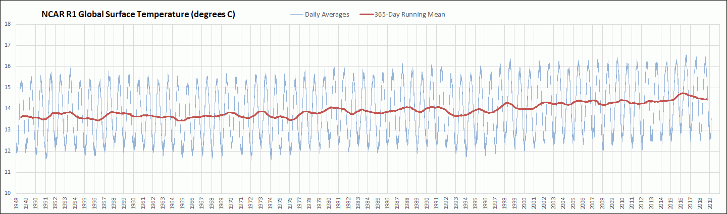
Figure 1. NCAR R1 Global MSAT 1948-2019

Figure 2. NCAR R1 NH MSAT 1948-2019
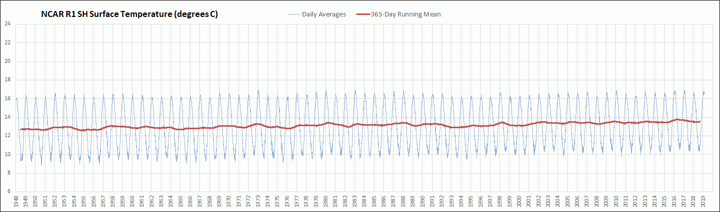
Figure 3. NCAR R1 SH MSAT 1948-2019
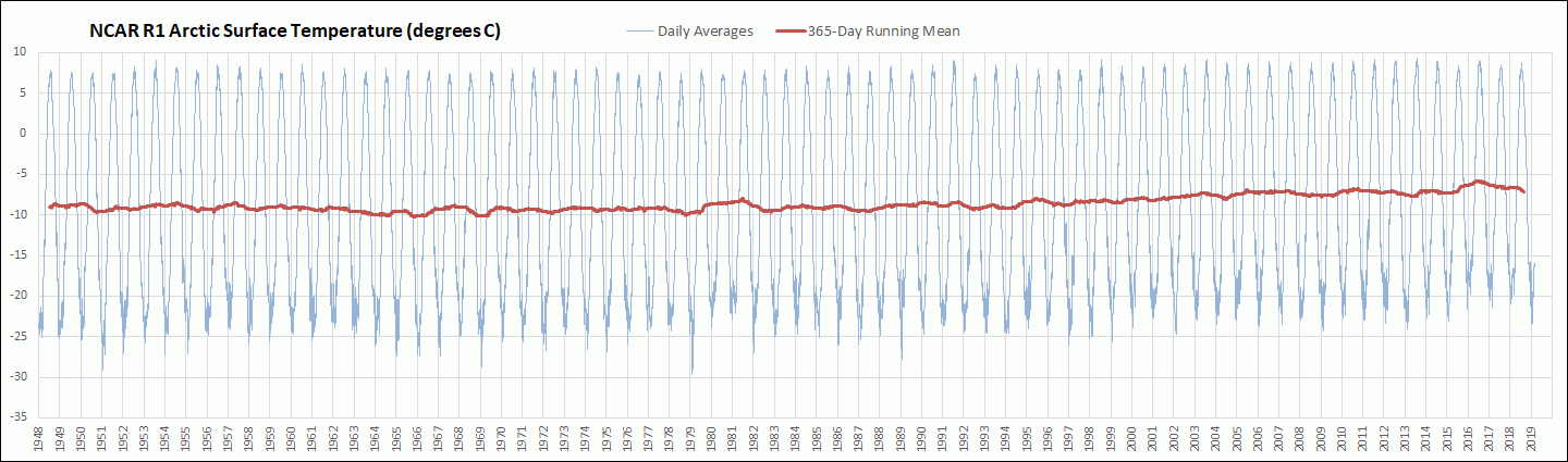
Figure 4. NCAR R1 Arctic MSAT 1948-2019

Figure 5. NCAR R1 NH Mid MSAT 1948-2019
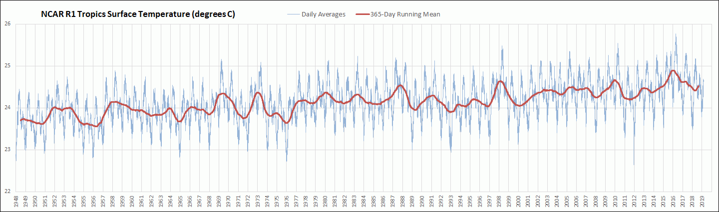
Figure 6. NCAR R1 Tropics MSAT 1948-2019
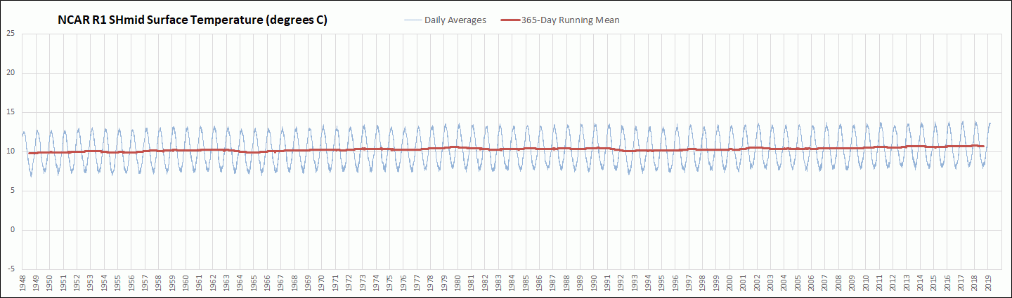
Figure 7. NCAR R1 SH Mid MSAT 1948-2019

Figure 8. NCAR R1 Antarctic MSAT 1948-2019
For a closer examination of temperatures during the current century so far (beginning 2001), I am providing Figures 9 through 14. These graphs are in the same format as the previous graphs, but show more detail because of the much shorter time span.
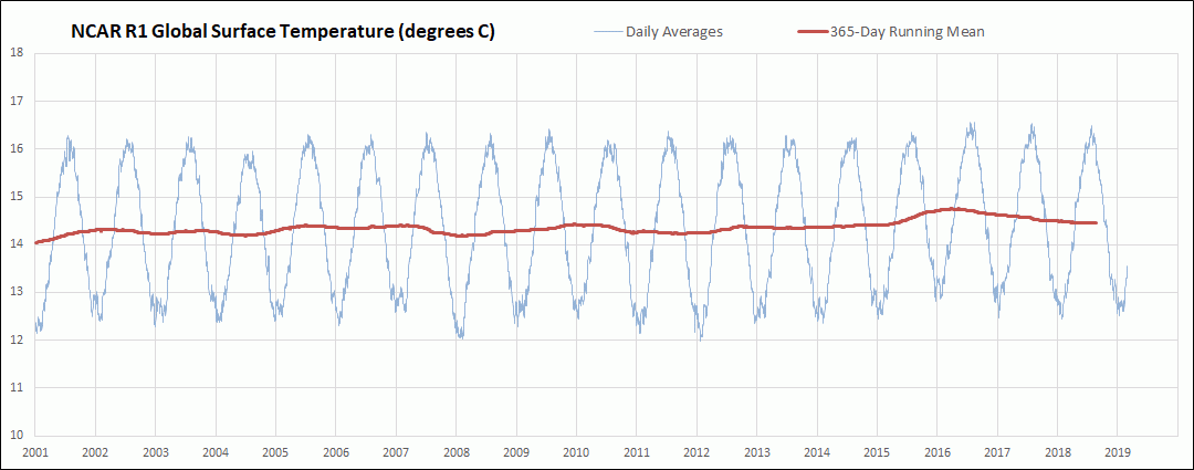
Figure 9. NCAR R1 Global MSAT 2001-2019

Figure 10. NCAR R1 Tropics MSAT 2001-2019

Figure 11. NCAR R1 NH Mid MSAT 2001-2019
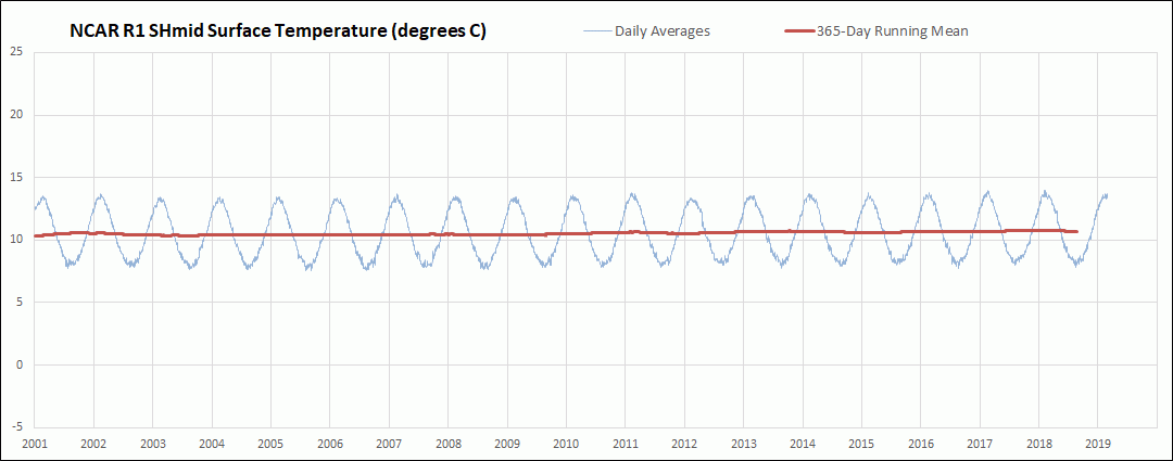
Figure 12. NCAR R1 SH Mid MSAT 2001-2019
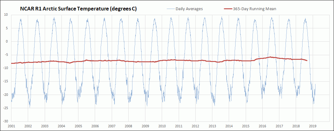
Figure 13. NCAR R1 Arctic Mid MSAT 2001-2019

Figure 14. NCAR R1 Antarctic MSAT 2001-2019
In the last set of graphs below I have isolated the 365-day running mean temperatures for comparison. Click on any graph to see a larger image.
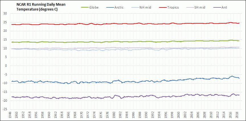
Figure 15. NCAR R1 Global and Zonal 365-day running MSAT 1948-2019

Figure 16. NCAR R1 Global and Hemispheric 365-day running MSAT 1948-2019

Figure 17. NCAR R1 Tropics 365-day running MSAT 1948-2019
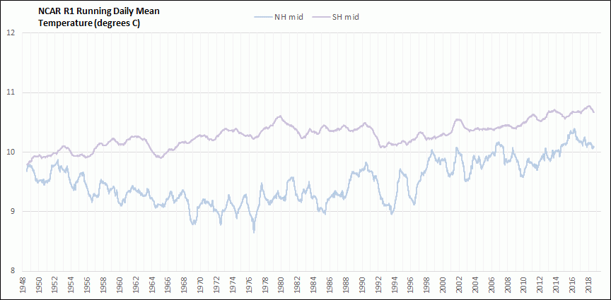
Figure 18. NCAR R1 NH Mid and SH Mid 365-day running MSAT 1948-2019

Figure 19. NCAR R1 Polar 365-day running MSAT 1948-2019
I will let the graphs speak for themselves rather than trying to offer any interpretation.

Reblogged this on Climate- Science.press.