
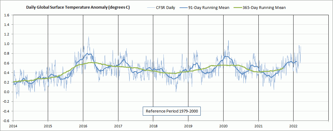
This post provides a quick comparison update of two different reanalysis daily global mean surface air temperature anomaly (GMSATA) time series for 2014 through 2022 March 19. The graph in Figure 1 shows the daily GMSATA time series for the Climate Forecast System Reanalysis (CFSR) output based on the Global Forecast System (GFS) initialization output four times each day. The temperature output is for the atmosphere at 10 meters above ground level. The CFSR model uses a 0.5 degree latitude by 0.5 degree longitude grid.
The graph in Figure 2 shows the daily GMSATA time series for the Sigma 0.995 level output from the National Centers for Environmental Prediction and National Center for Atmospheric Research Reanalysis 1 (NCAR R1) cooperative effort. The Sigma 0.995 level corresponds to the pressure altitude at 99.5 % of the surface air pressure, which is roughly about 50 meters above ground level. The actual height above ground level varies somewhat depending on atmospheric conditions. The NCAR R1 model uses a 2.5 degree latitude by 2.5 degree longitude grid.
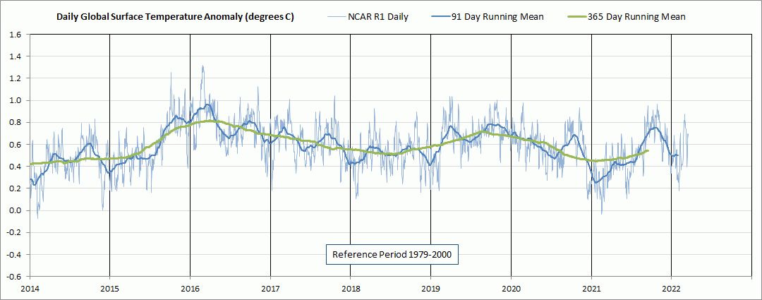
Figure 3 provides the NCAR R1 daily GMSATA time series for the current century beginning in 2001.
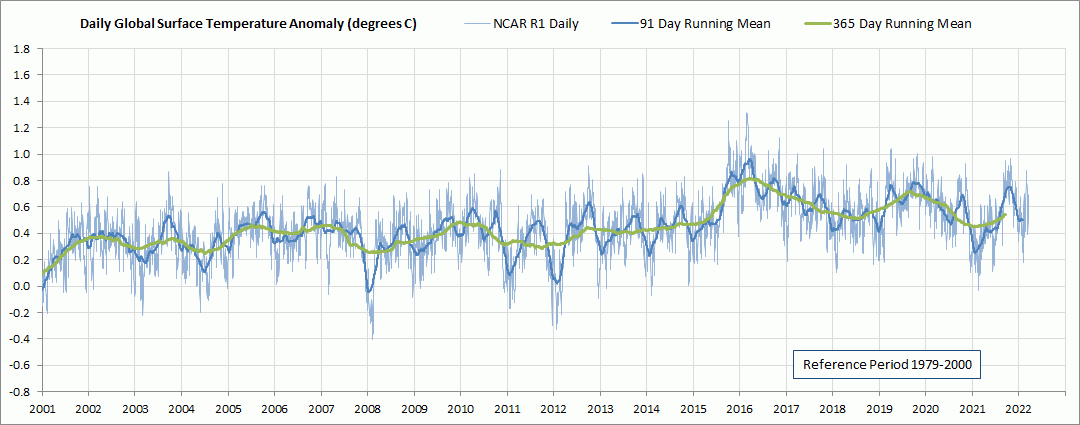
For a broader perspective, Figure 4 provides the NCAR R1 daily GMSATA time series for its entire period of record, beginning in 1948.


Reblogged this on Climate Collections.
Thank you for excellent and interesting graphs!
Perhaps the most intriguing graph is figure 3, demonstrating NCAR R1from 2000 to present. It does seem quite obvious that the 365-days running mean in 2022 will not come close to being 0,4 degrees higher than it was in 2002, which would be expected if global temperature rises by 0,2 degrees per decade, which is often stated. Obviously this is partly explained by ENSO variation, as we had weak el Nino conditions in 2002 and we now have weak/modearate Nina conditions. Nevertheless, even with neutral ENSO it does seem unlikely that the 365-day running mean will become much higher than 0,6 this autumn. Have you estimated a linear trend for the period in figure 3? Best regards Tor Ole Klemsdal, Oslo.
Tor, thanks for your comment. I agree with your assessment. I just finished updating the NCAR R1 data through April and at the end of April the GMSATA was back down around 0.4C for the last week or so. What will happen the remainder of this year is difficult to predict, but I doubt that a linear fit would help in that regard (I have not done so for this graph). You probably have noticed that in Figure 3 the GMSATA was nearly flat from 2002 through 2014 and since the El Nino related peak in early 2016 there has been a downward trend. The weak La Nina at present is forecast to weaken later this year, although confidence is low. I would not be surprised if the gradual downward trend since 2016 continues for a few more years, but time will tell.
What is your estimate concerning AMO and its effect. AMO so far: 1900-30 negative, 1930-63 positive, 1963-95 negative, 1995 – positive. We will probably see AMO turning negative by 2027. Is it possible that it would mean a 0.4C – 0.6C drop in global mean temparature by mid 2040?
Ilkka, I’m not an expert on the AMO, but from what I have read it does appear to be involved with cycles in Arctic sea ice and thus could potentially effect global mean temperatures in the next decade or two. There are already signs that the Arctic annual minimum sea ice extent has leveled off for more than 10 years now, and thus may be reaching the low end of the Arctic sea ice cycle.
I will be turning 70 soon, so I hope I live long enough to find out by 2040, although the trend toward increasing Arctic sea ice may be obvious even by 2030. Increasing Arctic sea ice would greatly contribute to decreasing global mean temperature, since most of the global mean temperature rise in recent decades is from the Arctic Region.
Thanks. I will be 70 November this year… I have a feeling that by 2030 we will see a clear trend.